Home
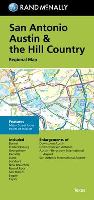
SAN ANTONIO AUSTIN & THE HILL COUNTRY REGIONAL MAP
Barnes and Noble
SAN ANTONIO AUSTIN & THE HILL COUNTRY REGIONAL MAP
Current price: $8.99
Barnes and Noble
SAN ANTONIO AUSTIN & THE HILL COUNTRY REGIONAL MAP
Current price: $8.99
Size: OS
Loading Inventory...
*Product information may vary - to confirm product availability, pricing, shipping and return information please contact Barnes and Noble
Rand McNally's folded map for San Antonio Austin & the Hill Country is a must-have for anyone traveling in and around this part of Texas, offering unbeatable accuracy and reliability at a great price. Our trusted cartography shows all Interstate, U.S., state, and county highways, along with clearly indicated parks, points of interest, airports, county boundaries, and streets. The easy-to-use legend and detailed index make for quick and easy location of destinations. You'll see why Rand McNally folded maps have been the trusted standard for years. -Regularly updated. -Full-color maps. -Clearly labeled Interstate, U.S., state, and county highways. -Indications of parks, points of interest, airports, county boundaries, downtown & vicinity maps. -Major attractions & Golf Courses. -Enlargements of Austin downtown, San Antonio downtown, Austin-Bergstrom Intl Airport, San Antonio Intl Airport. -Easy-to-use legend. - Detailed index & Major Street Index. -Convenient folded size. Coverage Area: Communities included, Burnett, Fredericksburg, Georgetown, Kerrville, Llano, Lockhart, New Braunfels, Round Rock, San Marcos, Seguin, Taylor. Product Details: Measures 9.5' x 4' and folds out to 40' x 28'.